Translate

Saturday, May 5, 2012

Day 20---California Here We Come (Right Back Where We Started From)

Got up bright and early to go east, back to Dinosaur National Monument.  I was so impressed by Pat's senior pass to National Parks that I bought one for myself.  What a deal, only $10 for a lifetime pass to federally run parks, monuments, forests, etc.

A real fossil, not a reproduction
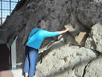
Careful there, Pat
We were very impressed by the Visitor Center, but were totally amazed by the Fossil Bone Quarry.  They have literally enclosed a side of one hill in a building.  This is new this year, and very nicely done.  The side of the hill is a "log jam" of fossil bones.  One hundred twenty five species have been identified, and Pat and I couldn't help but wonder how many more are still undiscovered.  You are encouraged to put your hand on real 149 million year old fossils, as you see Pat doing.
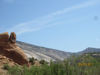


Blue Mountain
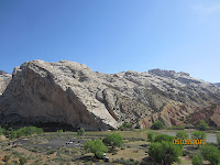
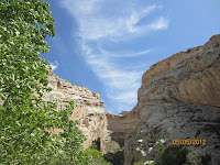
Split Mountain, with the
Green River at its base
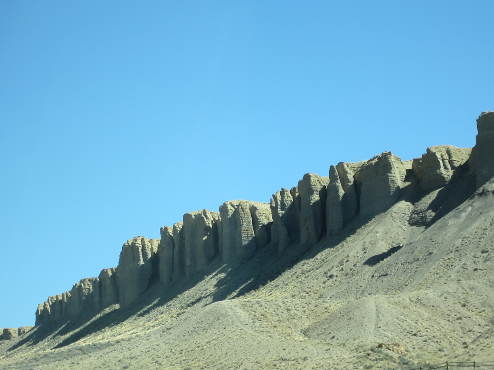
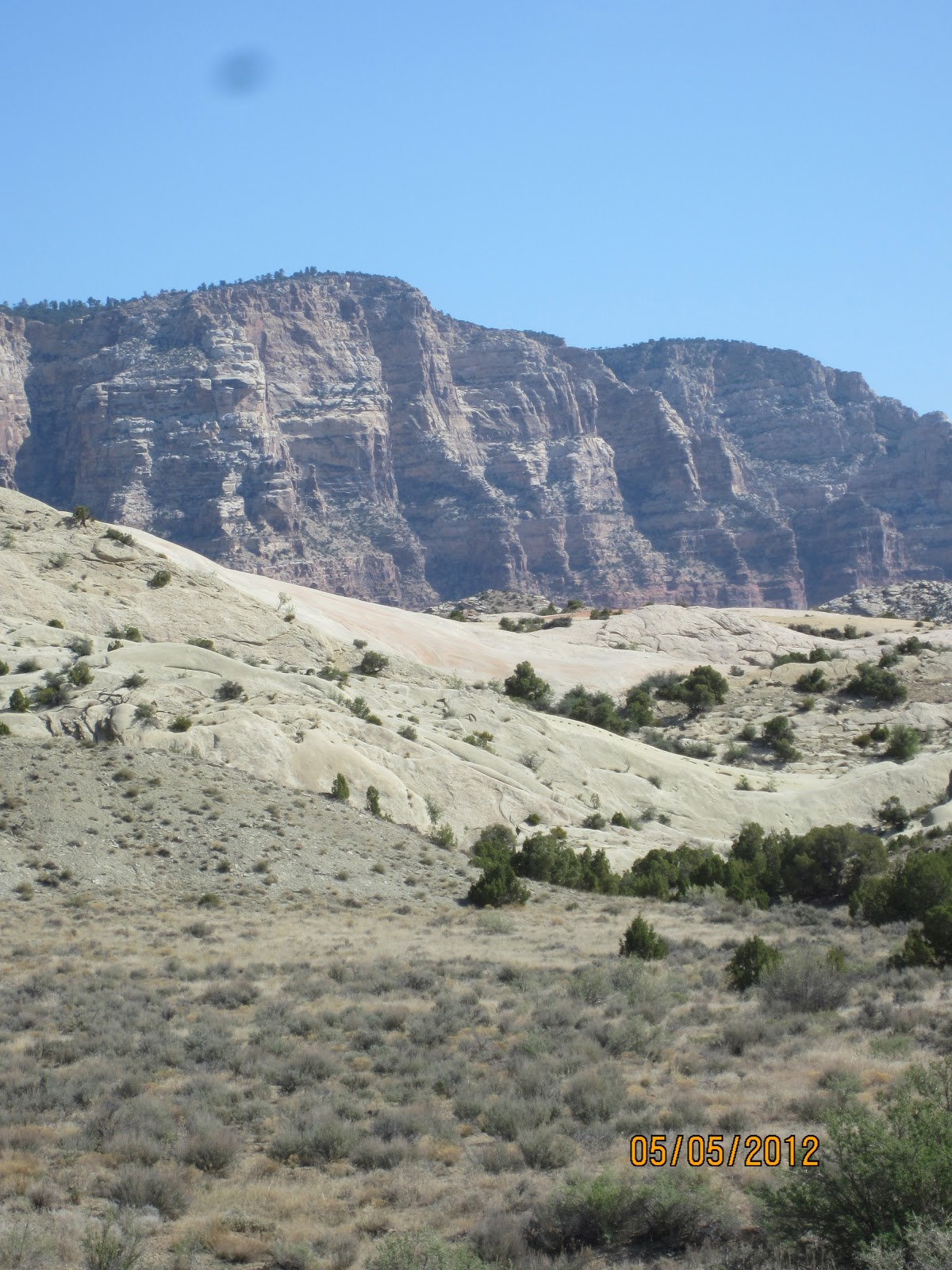
 We headed out on a car tour of a small part of the 325 sq mi Monument.  This picture is of Blue Mountain, which we saw when we entered Utah yesterday.  Much of the scenery is due to erosion by the Yampa River, which we saw yesterday, and the Green River, the major tributary of the Colorado.  Split Mountain, which is actually older than the Green River, is visible because of erosion of the Green River, which starts in Wyoming.

Here we are at the level of the Green River, looking at the pink banded cliff of mud and sandstone.  It is called the Morrison Formation and is important because many fossils have been found in its layers in the park.  It was laid down 149 million years ago by a large river that existed in this area then, and in which the dinosaur carcasses accumulated, to be covered by sand and mud and eventually fossilized.


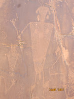
The Monument is filled with petroglyphs made by the Fremont People about 1000 years ago.  They used sharp rocks to chip out figures from dark natural stain on the rocks.  Many shapes are visible, like lizards, big horn sheep and people.  No one knows the purpose of these and their meaning is unknown. 


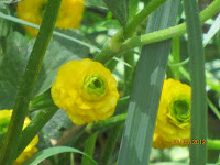
Flowers growing near Josie's spring
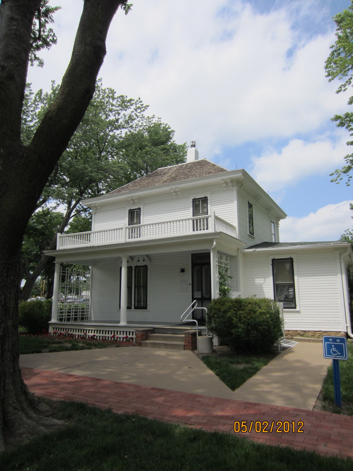
The end of the tour is at a homestead of Josie Bassett, built by her in 1935.  A real legend in the area, she raised all of her food herself, raised cattle, and generally lived the life of a 19th century rancher in the 20th century.  A natural spring waters the area, box canyons were used as corrals, and no electricity was available.  Her log cabin is very spacious, with four rooms and nice large windows.
The end of a box canyon used as a corral

In 1964, Josie died at 89 after breaking her hip.  


Looking back the way we came. we can understand
why Josie Bassett wanted to live here.  What a view!


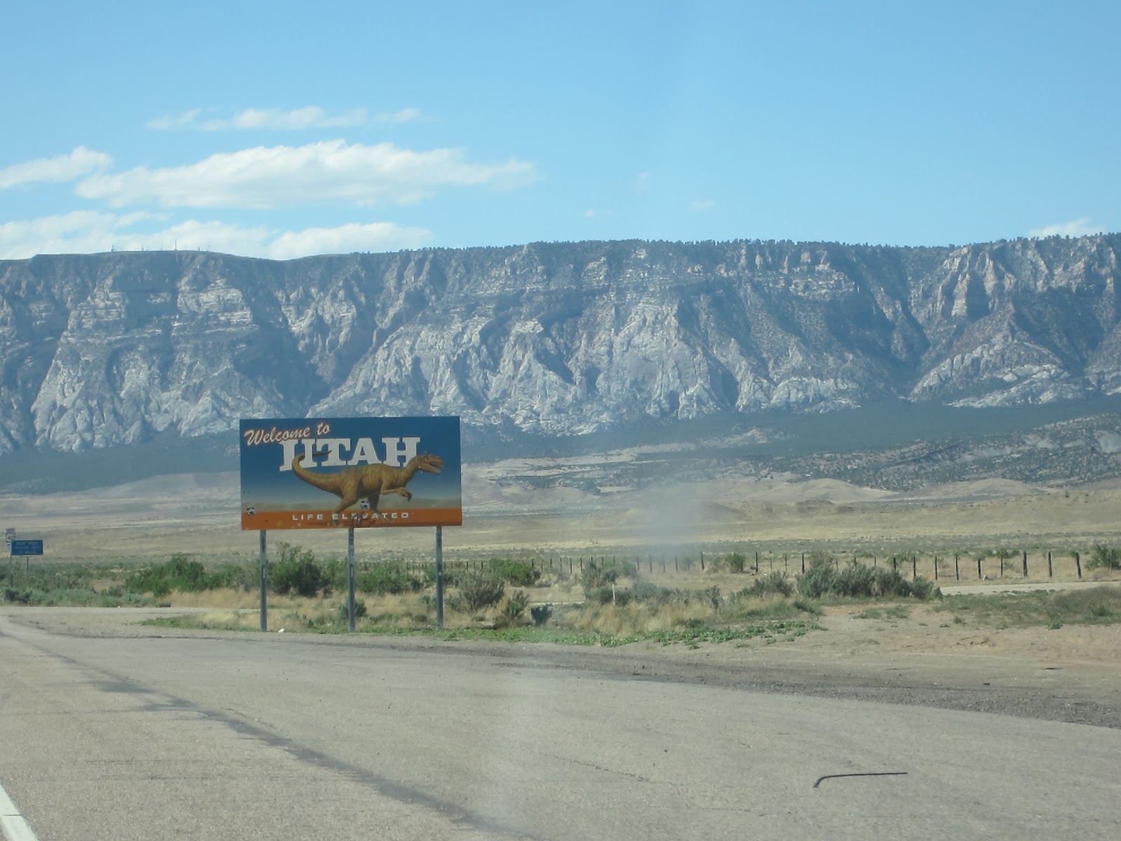
Leaving the civilization that is Vernal UT behind us, we set out to at least get to Salt Lake City.  We are on a high plateau, most of the time at 6000 feet or better, with some passes at 8000 feet.  You forget you are so high until you get out of the car and realize it is only 60 degrees.  Finally came off the plateau through a very long canyon into Heber Valley.  Houses and people everywhere, this after three hours of lonely road, often with no other cars in sight for miles.
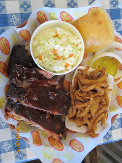
Serious yummmmm!
Looking for a place to eat, we saw a bar-b-que place called Dickey's in Heber City.  We were good yesterday, and hadn't had bbq yet, and it was late, and we were hungry, 'nuf said.  Wow, what wonderful bbq.  Had ribs, which fell off the bone, cole slaw, fried onions pieces, and a roll.  We were told that Dickey's is a national chain and is in California...Pat has a new favorite bbq place in Roseville now.  Seriously good, google it to find a place near you.

Heber Valley is just over the (large) hill from the Winter Olympic site in Parker City, which is just up the road from Salt Lake City.  We were very soon in SLC, coming onto it suddenly, very similar to how fast Denver appears.  SLC appears suddenly as you drive along a very twisty canyon.  We were soon out, also, as the road surface was much better than Denver or St Louis.  We sped along Great Salt Lake, and were soon passing the Bonneville Salt Flats.


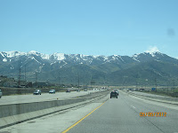
On I-80 heading toward the
Wasatch Mountains

At least in Utah you can see
where you're going

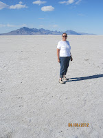
Mary Ann and the Flats
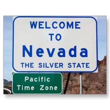
The sign welcoming us to Nevada was very welcome. As much as we love quilting and love travel, our own beds are calling us.  What is it about sitting in a car for eight hours that totally exhausts you?  Pat declared that she could make it to Elko, and so it was.  By the way, she now uses cruise control like a champ.
No quilt shops today, but tomorrow we're meeting Pat's cousin, Jerrie in Reno and going to a quilt shop there ;-)

State 15

Friday, May 4, 2012

Day 19---Rockin' Rockies, but not a quilt day

Perhaps a glacier at one time?
Just out of Denver
We left Golden bright and early this morning, heading west of I-70.  Mountainous, but nothing special until we come over a rise and saw this ahead of us.  Wow!  Turning off I-70 onto US 40, the old trans-continental road, we were soon in some spectacular country, with no traffic.  We soon discovered why.


Perhaps a truck deterrent?
James Peak Wilderness
The scenery was unbelievable.  Miles and miles of mountain road with snow still on the side.  We soon came into the Frasier Valley, and the town of Fraser (Yes, they are spelled differently.)
Frasier Valley
Fraser has the distinction of being the town with the lowest average temperature in the lower 48.  The average temperature is 32.5 deg, with an average growing season of 4 to 7 days.  What can you grow in 4 to 7 days?
A shallow cold Colorado River
We passed through Byers Canyon, a narrow place with only room for the road, the Frasier River and the railroad, a track on which the California Zepher runs.  Entering the next valley, the river became the Colorado.  It is a small stream here, with many points for fishing access, as it is shallow and used by a good number of fly fishermen.  Thought Surani and Rob would be interested in seeing the Colorado so small.
Byers Canyon


Probably 300' high
There are many interesting geologic formations, but Pat and I especially liked this one.  We were probably at 8000 ft altitude at this point, so this is high in the Rockies.  Looking backward at this point, it is hard to believe that we came through that range of mountains.
What we came through

Today was our day for seeing wildlife.  In the
picture on the right is a herd of prong horn 
antelope just off the road.  We also saw a 
coyote, who crossed right in front of us, 
and prairie dogs along the road.


Look closely!

On the left coast now.


We crossed the continental divide at Rabbit Ears Pass, so named because the mountain near it had two chunks of rock that stick up like (tah-dah) rabbit ears.  It was actually not too cold here, although there was snow on the ground, as you can see.  Just past this spot was a little meadow with interesting colors of vegetation among the melting snow.
Near Rabbit Ear Pass

Steep descents soon faced us...the sign next to this stretch warned that there was a steep grade for the next seven miles, with a runaway truck ramp three miles down the road.  Very similar to coming out of the Sierra, including the twisty turny road like the one on Hwy 20 going into Nevada City...except we were going into Steamboat Springs.


A ski jump just
down the street
Steamboat Springs is a very nice small town of about 9000.  It is also a world class ski area.  The downtown is filled with small shops, old stores, very fou-fou (code for pricey).  Pat and I had a good time looking around:  we went into several shops, including "Sew Steamboat" and a very nice (for Pat) candy store.  Notice in the picture to the bottom right that the flowering plums are in bloom.
Pat heading for candy!


Too early to eat, we were soon on our way again through the Yampa Valley.  Very high, some what dry, lots of cattle pasture.  We drove to Craig CO, where my phone told me there was a quilt shop.  Perfect!  we'd look at the shop and then ask where to eat.  The shop is called "Quilters Quest" and is a small shop, but with a good selection of fabrics and a very friendly owner.  She recommended we eat at a restaurant named "Carelli's," so we did.  Both Pat and I had salads, a healthy eating day.  In case you're ever in Craig, we would recommend it...they do a great pizza too, we're told.  
Left, Carelli's chicken salad (Mary Ann)
Right, spinach with walnuts (Pat)

 We left Craig and headed, we hoped, to Dinosaur National Monument.  No motel worth staying at in Dinosaur CO, crossed the state line to Jensen and realized it was too late to go the the visitor center of the Monument today.  No motels in Jensen, so we drove about 15 min west to Vernal UT where we are  spending the night.  We will drive back to the Monument tomorrow morning.

State No. 15, Utah
Blue Mountain range in background


Looking at Dinosaur National Monument

Thursday, May 3, 2012

Day 18---We're not in Kansas anymore

Have I mentioned flat?


 I have a difficult time getting over  how flat western Kansas is.  You can literally see forever.  Unfortunately, there is nothing to see in forever.  Not really boring though, and at least it's green, mostly. Have seen little corn, too early, but lots of wheat.

We stopped at a quilt shop called "Quilt Cabin".  A really nice shop with lots of fabric, but a unwelcoming saleslady.


Van Gogh to the extreme
You can see this Van Gogh reproduction of a Sunflower from the I-70 as you drive by Goodland KS.  The painting is 80-feet up on an easel, and measures 20 x 32 feet.  One of seven planned in the world, with two others done in Australia and Canada, it was painted by Canadian artist Cameron Cross.

Pat and I got off the freeway to look at it.  Goodland was chosen because many acres of sunflowers are grown in this area, Kansas being the 3rd largest producer of sunflower seeds in the United States.

Notice the size of the water tower...it is approximately the same height as the painting, also notice Pat's car in the background.

A close-up, or
as close as we could get!


I think our 13th state on this road trip
It says Welcome to Colorful Colorado


Goodland is in the far west of Kansas, actually where the time shifts from Central to Mountain, so we are one hour closer to home.  We soon crossed into Colorado along the largest stretch of roadwork we have seen.  The road on the north side has actually been totally ripped up to the dirt, and they're starting all over.  I envision a summer of miserable driving on I-70.  Not too bad this early in the spring, just lots of semi's.

Strange how much like Kansas the eastern part of Colorado looks?  :-)  They grow lots of wheat and sunflowers and corn here also.  This is wheat.  You can see just about forever here too, but the clouds have changed to little New Mexico like puffs.  More washes and arroyos now, with pasture and cattle.  Very definitely high plains, I can just imagine bison thundering over the ridge line.
Think wagon trains west, and how they felt.

Yummm, yet again
 We stopped in the little town of Limon CO for lunch.  Asked for a place to eat, and were directed to Ruby's Diner.  Very western motif, and good food.  Both Pat and I had a brangle melt which consisted of sourdough bread, a hamburger patty, provolone cheese, grilled portabella mushrooms and onions, with a small side salad. Good grub.

You should know that we are actually only eating two meals a day, so it really isn't as bad as it seems.


Rolling plains as far as can be seen, and suddenly a high rampart of mountains stretching north and south as far as can be seen.  The Rockies seem to rise abruptly from the rolling plains, and look formidable, snow-topped as they are.  I can imagine the 49's going "Now what?" as depression sets in at what they now have to do, after having gone through so much already.  They were certainly nothing if not determined.
Followed by this. Yes, that's snow.
High plains...


Coming suddenly into Denver, the traffic was terrible.  I mean "suddenly" literally, because we went from hardly any traffic to city traffic within two miles.  I don't have a clue where all the cars came from, but there they were.  Construction and torn up lanes, interchanges, etc.  Not quite as bad as St. Louis, but close.  We traversed Denver north of downtown, and saw the golden dome of the state capitol in the distance.  We have stopped for the night in Golden CO which is a little west of Denver.  The downtown is very historic, and reminds Pat and I of Nevada City (Traffic like Nevada City, too).  Actually the foothills of the Rockies, and after all the flat, a nice change.  This is where Coors beer is made, little did we know.
Coming into Golden
CO


Wednesday, May 2, 2012

Day 17---Prairie Postings

Peculiar MO
Left Clinton after doing our laundry in a convenient, clean laundromat across the street from the motel.  Still have not called Gogi and Ranbir--figure I'll wait until it is funnier than it has already become (see yesterday).  One the road before 9:00, are we ever efficient! Driving NW we encountered the peculiar town of Peculiar, which is in Cass County (more about this a little later).  The town motto is "Where the 'odds' are with you." Think about it.
Couldn't get the County of Cass sign, so the Parkway is going to 
have to do.  This is in honor of my oldest granddaughter Cassandra,
aka Cass.  Cass, this road sign is for you.  

For you, Cass
How many states is it now?
We were soon in Kansas City, Missouri, immediately followed by Kansas City, Kansas;  we're now on I-70, which we will follow for many miles, about 700 actually (Is Kansas ever a wwwiiidddeee state!).
Notice how far the road goes, and goes, and goes
We enjoyed the rolling hills of eastern Kansas---it is here that I-70 is a toll road, only $2.50 though, so not bad at all.  We were off the toll road at Topeka, then through Lawrence, where Pat and I agree we could live (except for humidity, are we Californians ever spoiled).  Passing by Junction City, I tried to take a picture for my sister-in-law Raghbir, who lived there when she first came to the United States, but could see nothing that was "pictorial."

 We soon saw road signs for Grandma Hoerner's Foods and Factory.  Hmmmm, a factory?  Since it was literally a stone's throw from the freeway, we stopped.  It really is a factory, and they were making thick-sliced apple pie filling on the assembly line that day.  I bought Pat pumpkin butter, hopefully a favorite which she can order again on-line.

Outside Alma KS
 Road cuts and rocks always interest me, and Kansas has some beauties, with lots of color.  You could almost expect to see something like this in New Mexico or Arizona---hey, wait a minute, we did see something like this in New Mexico or Arizona!
Chapman, KS
We stopped at our first quilt shop called Mother and Me in Chapman KS.  This is a tiny town (with brick pavements, which is something I've never seen in California) that got hit really hard by a tornado three years ago.  "Extreme Makeover", if that's the name of the show that builds houses for people, came to the town and rebuilt a house for someone.  It is also the home of Joe Engle, Astronaut, according to the sign on the grain tower.

Joe Engle of Chapman KS
The quilt shop was small, run by two women who bought it because it was going to close and they needed to keep it open.  Very friendly, and Pat bought a kit that she's been looking for for a long time.


Place of Meditation
Abilene KS
Front of the Presidential Library
On the grounds
Eisenhower Center
We followed old US 40 from Chapman to Abilene, where we stopped at the Eisenhower Center.  This includes a Presidential Library, Chapel where he and Mamie are buried, a Museum, Visitors Center and his childhood home.  Very beautiful grounds, with trees, flowers and butterflies everywhere.  We enjoyed getting out of the car and walking around.
Dwight D. Eisenhower
Childhood home

For some reason Pat and I both feel that Abilene is in Texas,  which it's not.

Salida, KS
We continued following old US 40 from Chapman to Salida KS.  Two women from Kansas that I met in Paducah had recommended the quilt shop there, and we were not disappointed.  Pat and I have decided that two quilt shops in one day, no matter how nice, is almost fabric overload, especially after Paducah.  All of our children will be happy to read this, as we are spending their inheritance for cloth!

 We ate lunch in Salida, back onto I-70, and continued on for about 90 minutes to Hays, KS.

Did I mention flat?
Not quite Amarillo ( cf. Day 6)
Waving fields of grain


Tuesday, May 1, 2012

Day 16---Indians (native) and Indians (south asian)

Impressive doors at the Cahokia Mounds
State Historical Park
Woke up to thunder this morning as a storm passed over Mount Vernon IL.  The storm soon was over and we were on our way to Cahokia Mounds State Historical Park (also a World Heritage Site, one of only 21 in the United States and 936 world-wide).  The mounds most impressive, huge, with millions of cubic feet of dirt in them with many different sizes and purposes.  The largest is 100 feet high.  The people belonged to the Mississippian culture, and were active between 900 and 1500.  At its height there were about 20,000 residents, larger than London at that time.  The city declined and it is not known what happened to the inhabitants---or what group they became.

Water loving daisies at Cahokia
Left Cahokia, which is near Collinsville IL, and drove over the Mississippi into St. Louis.  Wonderful views of the Arch as we came into town, and also awful traffic.  Working on I-64 and there were narrow lanes with lousy marking, huge bumps, tractor-trailers, weird off and on ramps...altogether very stressful, but Pat made it!

Crossing the bridge into St. Louis


Missouri welcome


Pat and I at the Quilted Fox


We had heard from some ladies at Paducah about a good quilt shop in St Louis, so off we went, yet one more time.  Quilt shop was in a strange mall, but we found it.  Called the Quilted Fox, they had much oriental style fabric, which made Pat happy.  I found some paisley, which made me happy.  


We soon left St. Louis and headed west on I-64, and then I-70.  We ate lunch at Dairy Queen in Warrenton (no more Dairy Queen) and since there was a quilt shop only 1.5 mi away, what the heck.  It was in the Warrenton Mall, which has about 5 open stores, and about 30 empty stores: a ghost mall, if you will.  The quilt shop closed yesterday!  What great timing for us.


Rolling hills in west-central Missouri
After a (long) while we turned off I-70 to go to Clinton MO to visit cousins of my husband.  Called and talked to the husband, who said that they were going to Texas, and he would have his wife call me.  Major mis-communication--he did not tell me that at that very time he was on the road driving to Texas, and I thought he meant he would be going to Texas, not at that immediate time!!!!  Anyway, Pat and I drove to the middle of nowhere, aka Clinton.  Saw some beautiful countryside, very rolling hills, with trees, green wheat, unplanted corn fields, cattle.  Got to Clinton (finally), only to discover that the motel had been taken over by a very nice Gujarati couple, and Gogi and Ranbir were nowhere to be seen.  Oh well, I'll speak to Gogi later.  We took a motel room, and so here we are.